I’ve been asked a couple of times to show how I go about finding out potential places to go prospecting. There’s a lot of stuff that is just word-of-mouth, but there are also some free Tasmanian prospecting maps that you can use to get a lot of information.
MRTmap and LISTmap
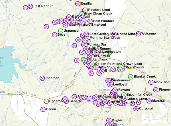
I gave a bit of information on online resources my previous post on the northeast goldfields, but here is a much more in-depth video on how to use the base maps and overlays in the free mapping engines to locate mineral deposits, and see the tenement information and land tenure information.
The two main map sites I use in the video are MRTmap and LISTmap.
This video is best watched in full-screen
Don’t be too shy about playing with MRTmap and LISTmap, there are a lot more information overlays than I could possibly cover in a short video. You can find information on geology, mining, reserves, vegetation types, roads, boreholes, you name it! If you combine this with Google-searching the MRT Library, as I described in my previous post, you can find out all the information available on just about any mineral deposit or tenement previously published in Tasmania.
Do you have any other useful Tasmanian prospecting maps or resources? Do you like the content at Apple Isle Prospector? Feel free to get in contact, or leave a comment.
thanks for doing what you do, also helps to keep me sane from all the day to day crap.
Thanks Dennis,
No worries, I’m glad you find it useful.
Hi just watched you Vid on MRT maps, I was wondering when you looked up some of these mines that they have abandoned on the info, does it mean just that or what
Hi Brendon, I’m not sure what your question is, sorry.
Can you be more specific?
23/10/2016
Hello Tasprospector,
I wonder if you could help me.
I have come across the following web page.
http://www.mrt.tas.gov.au/mrtdoc/dominfo/download/GSMR11_2/GSMR11_2.pdf
Which seems to have a considerable amount of information, along with substantial data on gold locations, it seems to have what I suspect to be GPS coordinates ( AMG E & AMG N).
Unfortunately I do not recognize the format of these coordinates.
I have the use of a Garmin GPS along with MapSource and BaseCamp, mapping programs, however, these programs seem not to recognize the above formats.
Are you able to advise me on how these formats can be converted to something my MapSource and or BaseMap programs would be able accept.
Regards,
Gabor Horvath
Hi Gabor,
The coordinates in the Alluvial gold booklet are UTM grid references. There are various conversion tools around the web you can use to convert to degrees. They are also a mix of mostly AGD66 datum, with some GDA94. Modern GPS uses WGS84 which is identical to GDA94. AGD66 is used in the older 1:25,000 and 1:100,000 Tasmaps. It is about 200m off from GDA94. Again, there are conversion tools kicking around, Google should help.
Keep in mind that most of those coordinates, if not all, are in my gold localities Google Earth .kmz file here, already converted to current, GDA94 datum.
Good luck!
Hello again TASPROSPECTOR.
Thank you very much for your super quick response and your help.
You saved me lots of headaches and time.
My wife and I will be visiting your great state shortly, we are from Ipswich (Near Brisbane).
I just purchased a Makro Gold Racer metal detector, as such, I hope to be making use of your detailed Gold Maps.
Thank you again, Regards,
Gabor
Hi you should start a club up ..ill join and so would heaps of others
Hi Glenn,
There is a club – It’s called the Prospectors and Miners Association of Tasmania Inc.